
|
2 half days to do Shimanami Kaido path: our story and practical information
A trip to Japan during fall part 3/7
Published
on
FEBRUARY, 2 2024

- Our journey to Onomichi and our bike rental
- Our bike tour
- Our journey accross Mukaishima and Innoshima islands
- Ikuchijima and our refreshing break at Shimagokoro SETODA Honten
- Our night at I-LINK HOSTEL & CAFE SHIMANAMI
- Our journey accross Ohmishima and Hakatajima islands
- Ohshima island: our detour at the Kirosan observatory park and the last bridge to reach Imabari
- From Imabari to Fukuyama
- QA for those who would like to do the Shimanami Kaido.
- What is the Shimanami Kaido route ?
- Are there any points to resupply along the way?
- How does the bicycle rental works ?
- Are there tolls to pay to cross the bridges ?
- How long does it take to do the whole route ?
- Are there cycling roads all along the route ?
- What to do if I have a backpack that is difficult to carry while travelling by bicycle ?
- What are the public transports available from and between Onomichi and Imabari ?
- Our opinion on Shimanami Kaido

The Shimanami Kaido is a very well-known route in Japan, in part thanks to its easy access for bicycles. It allows crossing 6 islands via bridges accessible to cars, bicycles, and pedestrians; connecting Honshu to Shikoku; but above all, enjoying magnificent landscapes.
Below, we share our experience with you, and if the adventure tempts you, you will find a little Q&A at the end of the article to help you organize it.
And if you don’t know what the Shimanami Kaido is yet, go here to get the detailed map.
Our journey to Onomichi and our bike rental
Our day starts in Kyoto. To reach Onomichi, our starting point for the Shimanami Kaido, we take the Shikansen. It is a high-speed train that reaches a top speed of 250 km/h.
We use our JR pass for the first time. It’s a kind of subscription that allows unlimited access to all the lines called JR (Japan Rail; this includes trains and buses) for a given period. Despite the information we asked for on when and how to use the JR pass, we’re a bit confused. In fact, to access the station and its local trains, we have to go through a first gate, and then a second one to access the Shikansen. Out of habit, to enter the station, we use the IC card, the card we’ve been using since the beginning of the trip, which allows us to pay for almost all the transportation throughout Japan. Then we use our JR pass to go through the second gate.
We didn’t follow the correct procedure and we should have used the JR pass at each of the 2 gates. So, we will see the agents to avoid paying extra the next time we use our IC card. The agent resets our card without really asking more questions about it. As always when we encounter « problems », the Japanese take us at our word, which greatly simplifies things for us and turns these « problems » into simple anecdotes.
Throughout this first use we notice that unlike the IC card, the JR pass is a simple piece of cardboard. For our part, we paid almost 300€ to access the services for 14 days, and every time we put it in the machine, we feel a bit anxious: a crease, a corner, and it’s game over. Compared to the IC card, which is a plastic card and is validated without contact, we find it flimsy but we’ll have to live with it.
Once all these little hiccups are over, we take the train. The journey to Onomichi is not direct, and we make a first stop at Shin-Osaka and a second stop at Fukuyama. It’s during this second stop that we leave our big bags in precious coin lockers. We pay to secure our bags for 2 days.
Then we take a train to Onomichi.
Upon our arrival at the station, we stop by a a 7/11 to buy our lunch. We find a picnic table near the sea. It’s hot, the sun is shining, it is perfect ! But a the end of the meal, we find ourselves with a stack of plastic that we need to get rid of. We look for a trash can, in vain: here, there are very few public trash cans for hygiene reasons. Our bags are already full and we can hardly fit all this plastic in. So, we decide to go back to the 7/11 to give them our waste and there we finally discover a trash cans at the entrance of the konbini. It’s a good lesson that we’ll know for the rest of our stay.
We then search for the bike rental. Eva enters an office thinking that it corresponds to the location we are looking for but it is not the case. Th employees barely dare to tell Eva that this is not the right place. The situation makes Nicolas and Kévin laugh.
Finally, we continue our way and see a myriad of bikes: we are at the right place. The rental process is very easy despite the fact that the employees speak very little English. The only problem is for Nicolas: the Japenese are smaller than Europeans and it shows in the size of their bikes. Nicolas takes the largest available bike but it is still too small for him…
Once equipped with our bicycles, we head towards the docks and the ferry departure point that will take us to the beginning of the Shimanami Kaido road. Indeed, the first bridge of the Shimanami Kaido from Onomichi is not accessible to cyclists, so we must take the sea route.
While waiting for the arrival of the boat, Kévin and Eva go to an info center to inquire about accommodations along the route. We have chosen not to book anything in advance to remain flexible in case of bad weather. Fortunately, the sun is shining, and we need to start thinking about where we will sleep. We are advised to go to Setoda Sunset. We also leave with a map that will be very useful.
Meanwhile, Nicolas stays near the dock and is approached by a student conducting a survey on people completing the Shimanami Kaido. The exchange takes place in English, and the student mentions that she has already done the route and that it is entirely feasible, but some sections are more difficult than others. This is not entirely reassuring, but now we have no choice.
Once the survey is over, she wishes us ganbatte, which means good luck.
The boat is arriving. We pay the required 110¥ for the crossing directly to the driver and 5 minutes later, we are on the first island, Mukaishima Island.
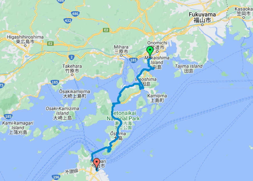
Our bike tour
The map below shows the route we have taken. To view it in full page, you can click here.
Our journey accross Mukaishima and Innoshima islands
We arrive on Mukaishima around 2pm, the weather is nice and pleasant (around 25°C). The marks indicating the Shimanami Kaido route is visible as soon as we leave the ferry and splits into two. On one side, there is the recommended route, and on the other side, an intermediate-level itinerary.
We head towards the recommended route. This allows us to get an idea of what the recommended route is like, to test the bikes, and to see how fast we are going.
We quickly realize that it’s a smooth ride. It’s flat, the bikes are convenient. However, we are on the road (there is no separated lane here), but there are very few cars, and the few that overtake us are very considerate, leaving plenty of space as they pass. This will be the case throughout the journey, and it’s very much appreciated.
We stop regularly to take photos but also to readjust the bikes and position Nicolas’ camera to film the journey.
We quickly reach the first bridge. The announced slope is 3%, and we climb to the bridge without much difficulty. This ascent, like all the ones to come, is enjoyable. Everything is well laid out: there are spaces to stop and observe, many trees are planted along the road, which provides shade and coolness, a coolness that we appreciate despite being in the middle of October.
Once the climb completed, we join the cycle path of the first bridge which is located below the infrastructure. We can hear the cars and trucks passing overhead. It’s quite impressive but at least we don’t have to worry about the cars.
After crossing the bridge and descending to sea level again, we tackle the second island. Once again, there are two possibilities: the recommended math or the confirmed one. We don’t hesitate for very long time to take the recommended route. An American who has already made the journey reassures us in our choice. He tells us that the other route is hilly, and the view is not significantly different from the one offered along the recommended route.
We listen to him, but without realizing it, we do not completely follow the recommended route and at some point, we branch off onto the intermediate route: if we do not notice it, it means that the intermediate level is very accessible.
We arrive at the second bridge which has a 3% incline once again. This ascent is shorter because the second bridge is simply not as high than the first one.
Ikuchijima and our refreshing break at Shimagokoro SETODA Honten
We arrive at the 3rd island and we decide to take the recommended route for several reasons.
The first is that a tourist info center is indicated on this route. It turns out that we won’t be able to find it but that’s a detail.
Also, before leaving, we inquired about our accommodation options. We were then told that Setoda Sunset Beach, located on this route, was a good choice.
Lastly, Ikuchijima Island is renowned for its high-quality lemons, and we hope to be able to enjoy them. We notice that Shimagokoro Setoda Honten, a store selling lemon-themed food, is also located on the route.
So we head in that direction. On one side, we have a view of the sea, and on the other, a view of the orchards.
We stop to buy a well-deserved lemonade at Shimagokoro Setoda Honten. It’s refreshing and for a few moments, it relieves us from the heat. The shop also offers many other lemon-based specialities, but we won’t be tempted for this time.
We then head to Setoda Sunset Beach. It’s very beautiful. The beach is heavenly and the gentle breeze there is very welcomed. However, despite looking around, we can’t find any accommodation. It turns out to be just a camping site where you can pitch your tent. We see several people doing so and we think they will have a great night. But that is not our case: we don’t have a tent, so we continue on our way.
We do a quick search on the internet and we see accommodations but only on the next island: we have no choice but to cross the 3rd bridge.
We pass at sunset and we couldn’t have dreamt of a better time to make the crossing!
Our night at I-LINK HOSTEL & CAFE SHIMANAMI
We arrive at the 4th island around 6pm and head to the I-Link hostel & cafe shimanami. It’s a hostel with a dining area and dorms. There’s still a bit of space left, and we didn’t expect there to be so many people outside of the peak season.
The dormitories are organized like a capsule hotel: each bed is neatly compartmentalized by walls and a curtain to close off its space. There are hangers to hang clothes and outlets to easily charge electronics. It’s simple but really well laid out.
There are also larger « capsules » with double beds or bunk beds. In these cases, the lockers are integrated into the capsule, which also has a small desk and a chair.
The bathroom and the toilet are extremely clean. The hostel provide all the necessary comfort with shampoo, shower gel, towels, slippers, pyjamas, cotton swabs, cotton pads, toothbrushes, toothpaste… In a nutshell, nothing to complain about.
Finally, a family mart is located across the street. Without hesitation, we head into the grocery store, which has a microwave to warm up the dishes we bought. We sit at one of the tables in the konbini. We appreciate these thoughtfully designed environments, especially since we are a bit tired from the day and are happy not to have to rush around.
We return to the inn to go to bed and we fall asleep like logs.
Our journey accross Ohmishima and Hakatajima islands
The sleep was very restorative: the dormitories were quiet and we were able to rest well.
It is only 8am and it is already quite hot outside. We head to the Family mart to buy our breakfast and eat it at the picnic table set up by the sea.
We use the tools provided by the hostel to adjust our bikes, and we fill our bottles with the lemonade offered by the establishment.
We take the shortest routes to cross Ohmishima and Hakatajima. The bridges are not high, and this beginning of the journey is a perfect warm-up.
Ohshima island: our detour at the Kirosan observatory park and the last bridge to reach Imabari
Arriving on Ohsima Island, we see on Google Maps that the Kirosan Observatory Park detour is highly rated and the associated photos are incredible.
We are perfectly on schedule, so we think we can take a detour.
The ascent starts at 5%, then 10%, and ends at 15%. We climb under the encouragement of the Japanese. Nicolas manages to reach the top without getting off the bike, but Eva and Kévin are not able to do so.
We are now a little over 300m above sea level. We no longer feel the wind, but the view is perfectly clear. We can observe the entire route taken, we see the bridges, the islands, the sea, it’s really worth a effort to be able to admire this view.
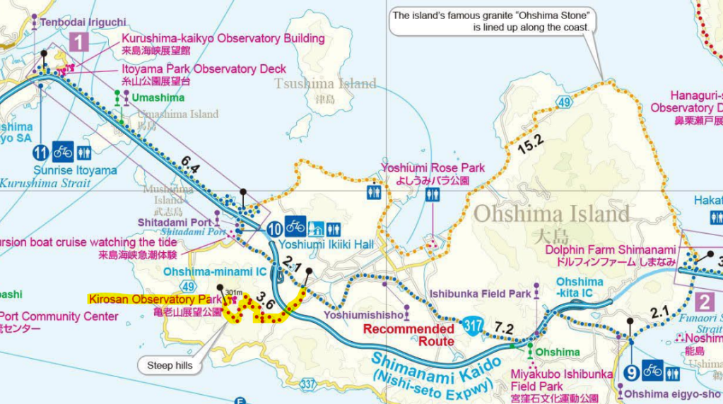
We descend very easily and in a hop, skip, and a jump, we are already on the last bridge. It is the longest and by far the most challenging. The ascent is finally done without too much difficulty, but it is once on the bridge that we have the most trouble moving forward. We have a nice headwind that bothers us a lot during the 6.4km crossing. This is usually the most impressive bridge. Cyclists take advantage of it to admire the view, but we cannot give you the same feedback as our minds were just focused on crossing it.
From Imabari to Fukuyama
Once the last bridge is crossed, we arrive in Imabari around 12pm and look for the bike station to return our faithful travel companions. We head directly into the city, where there are few or no bike lanes, so we ride like the Japanese, on the sidewalks.
We return our bikes to Imabari Cycle station and it’s a great relief for Kévin, who was starting to seriously suffer from butt sore. He will indeed walk like a cowboy in the days to come.
At the bike station, there is a tourist info center. The staff there speaks good English and we take the opportunity to confirm the starting point for our bus to Fukuyama. She confirms to us that the bus station is right in front of the office.
So we have time to stop by the 7/11 and enjoy a well-deserved meal. Once again, there are tables available in the shade and the sun, so everyone is happy.
This time, we directly take back our wastes to the 7/11.
We get on the bus to Fukuyama and then silence, everyone falls asleep. We arrive about 1h30 later in Fukuyama and we pay 2400¥ for the journey, which is about 20€.
We head to the train station and retrieve our bags from the coin-locker without any issue.
It’s about 5 pm and we only have to take the train to Hiroshima. The journey lasts about forty minutes, fortunately. We are in a « non-reserved seat » carriage. These are the only seats accessible with the JR pass without prior booking at the ticket office. Unfortunately for us, the carriage is packed to the brim, to the point where we even use the toilets to find a place. There’s an elderly couple in there, getting jostled with every shakes of the train. No one will give up their seat for them, and this is something we have seen many times.
Anyway, every experience is a good lesson, and Nicolas will make sure we have a reserved seat for the next journeys.
We arrive in Hiroshima at night and our first impression is very mixed. But we will tell you all about it in our next article.
QA for those who would like to do the Shimanami Kaido.
What is the Shimanami Kaido route ?
Above, we shared the route we took. However, there are different paths depending on your desires and your abilities.
Some paths take you on detours to see shrines, gardens. This adds distance but often involves just a little difficulty.
Other paths take you to beautiful viewpoints, but they require climbing. In this case, it’s better to have strong thighs and good cardio.
In general, staying on the outskirts of the islands is the easiest path: it’s flat and you’ll only need to climb before the bridges. If you venture deeper into the island, it becomes much hillier immediately.
Here is a first-hand account of someone who took a few detours to see the various points of interest offered and covered approximately 100km to do so: https://www.voyagesjapon.com/guide-du-japon/shimanami.html.
Here you can find the official route map: https://shimanami-cycle.or.jp/download/cycling/cycling_map_en.pdf
The blue dashed lines indicate the recommended route for the Shiminami Kaido; the yellow dashed lines indicate the intermediate route while the red dashed lines indicate the route for more adventurous cyclists. https://shimanami-cycle.or.jp/download/cycling/cycling_map_en.pdf
Are there any points to resupply along the way?
Yes, there are many points to resupply along the way. Like almost everything in Japan, everything is very well organized.
You will find convenience stores to buy snacks. You will often have free access to toilets at the same time.
You will also find water fountains in certain locations, and if you desire other beverages, you can either stop at one of the many beverage vending machines or at the grocery stores.
All these points are clearly marked on the official map that you can find via this link: https://shimanami-cycle.or.jp/download/cycling/cycling_map_en.pdf.
How does the bicycle rental works ?
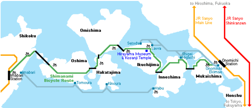
Various rental stations are scattered throughout the route. This means that you can start more or less from wherever you want, and finish where you wish.
Below, you will find the Google Maps locations of the bike rental shops that we have used.
- Bicycle station at Onomichi: Onomichi port Bicycle rental terminal
- Bicycle station at Imabari: Imabari Cycle station
This map shows the bicycle stations available along the route.
From our side, we paid 3000 ¥/day/person. Prices regularly change, so make sure to verify that those communicated here are still up to date by using this link https://shimanami-cycle.or.jp/rental/english.
Another company offers a bicycle rental service: https://bicyclerental.jp/en/lineup/. Its services are currently more expensive but allow access to a wider range of bicycles. It should also be noted that this company currently only has two terminals: one in Onomichi, the other in Imabari. There is no other choice in this case but to make the entire journey.
Are there tolls to pay to cross the bridges ?
We did not have to pay any tolls, but I read on Japan Guide that this is a temporary measure to promote tourism. This measure is set to end on March 31, 2024, and its reinstatement would mean paying ¥500 for the entire toll road. I couldn’t find this information on other sites. If you are traveling after March 31, 2024, it may be worth revisiting the subject.
On the other hand, the first bridge from Onomichi (the last from Imabari), which leads to Mukaishima Island, is not accessible to cyclists. You will need to take the ferry from this point. You will pay for your ticket upon boarding. In our case, we had to pay 110 ¥ per person for the crossing (100¥ per passenger + 10 ¥ per bicycle). The crossing takes barely 5 minutes.
How long does it take to do the whole route ?
If you follow the recommended route, you will have to cover around 70km with a low elevation gain. The only incline you will encounter will be 3% at the entrance of the bridges and 5% at the entrance of the last bridge. The official website of the Shimanami Kaido indicates that for experienced cyclists, only 4-5 hours will be necessary; 5-6 hours for an intermediate level. These durations correspond to the minimum time you will need, but I believe that if you want to fully enjoy the experience, it is interesting to give yourself some extra time to take photos, eat local specialities, admire the viewpoints, stroll on the beach, look for a place to sleep… And on this point, only you know how much time you want to allocate for it.
Are there cycling roads all along the route ?
There are bike paths for most of the route. When there are none, you can ride on the road without any worry, as the Japanese are very respectful of cyclists and leave a significant safety distance. Otherwise, you can always ride on the wide sidewalks like the Japanese do.
What to do if I have a backpack that is difficult to carry while travelling by bicycle ?
You can do as we do and leave it in a locker at Onomichi, Fukuyama, or Imabari depending on your plans. It is also possible to have your luggage(s) being transported from one point to another if you do not wish to backtrack. Sagawa offers this kind of service, for more information you can click on the following link https://www.sagawa-exp.co.jp/stc/english/.
What are the public transports available from and between Onomichi and Imabari ?
There are bus and ferry systems between the islands. This allows for the possibility of stopping along the way; not making a round trip, or simply visiting the islands using these means of transportation.
Below you will find a map that I found on Japan Guide which is detailing the different options.
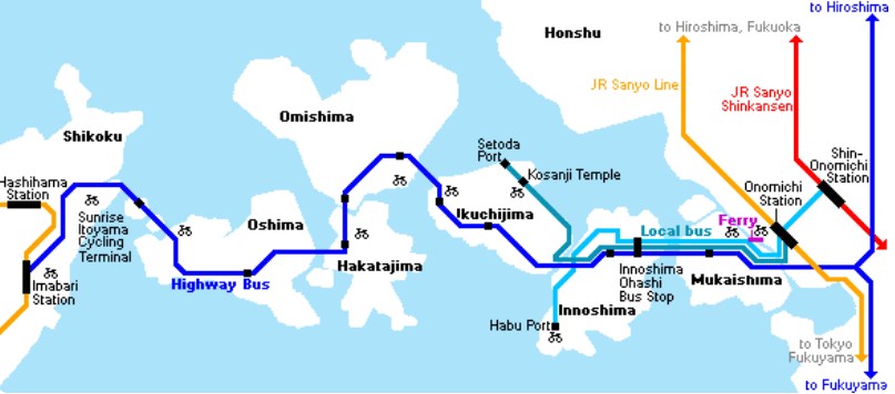
The « highway bus » that departs from mabari and arrives at Fukuyama takes 1h30 and costs 2400¥. Bus departs every hour.
The « highway bus » thst departs from Imabari eand that arrives at Hiroshima takea 3h and costs 4200¥.
You can easily retrive those information that will remain updated via Google maps or thanks to the info centers that you will find at Onomivhi and Imabari.
Our opinion on Shimanami Kaido
We loved taking this little bike ride: everything is very well thought which will make your journey very enjoyable. And what can we say about the view…!
The course is accessible to everyone and you just need to know how to choose the route that best suits your level and desires.
We also enjoyed having time to do it. We were mostly there to have a good time, to contemplate magnificent landscapes rather than to be in a sporting challenge. It’s up to you to decide why you’re making the trip for and to adjust the time you spend there accordingly.
Finally, doing it in October was not a problem, far from it. We had beautiful sunshine throughout the journey. The temperature was perfect (around 25°C) and we were sufficiently off the tourist season to feel like we were alone in the world.
Furthermore, we also know that we were very lucky and that autumn in Japan is supposed to be colder and rainier, but who knows, maybe autumn 2023 is representative of the autumns to come, which will be increasingly mild and sunny?
We hope we have inspired you to try the experience, and if you have any remaining questions or concerns, feel free to leave them in the comments.
Our other articles about Japan

The budget for a pleasure trip to Japan
How much does a post-Covid trip to Japan cost? We present here a detailed and commented article on our expenses to help you best estimate what you can expect to spend on your trip.

4 days in Kyoto: between tradition and modernity
We continue our trip to Japan with the ancient Japanese capital of Kyoto. We tell you about our 4 days between modernity and tradition.

An unforgettable and guenine night in a ryokan
Our trip to Japan was motivated, among other things, by a desire to experience Japanese culture from the inside. When we heard about ryokan, those typical and rather unspeakable Japanese accommodations, we thought we had to add it to our program. After canvassing the market, asking around a bit more and finding establishments that could…

At Nahoko’s to learn how to cook Japanese and gluten-free dishes
What about learning how to cook delicious and typical Japanese dishes without gluten? That’s what we did during our stay in Tokyo. We went to Nahoko’s to learn how to cook delicious ramen: from the noodles, to the broth everything is homemade and gluten-free.

A glimpse of Osaka and a lot of fun in Universal Studio Japan over 2 days
2 days to visit Osaka, this is the time we had to discover this city. We mainly visited Universal Studio Japan and we detail our immersive and unforgettable experience in this article

Laisser un commentaire